
For landscape photographers, two things are crucial: location and light. The former can often be difficult to find while the later is highly variable. However there are extremely useful (free) tools out there to make our lives easier. In this article I cover the 4 key sites that I use to research and plan my landscape shots.
Google Maps

You're probably quite familiar with Google Maps to check directions, but it's worth drawing attention to the satellite view overlay which would be my single most used tool in planning photo expeditions, and even more so if I've never visited the location before.
It's extremely useful when I come across a photo of a new, interesting spot and then want to locate the area the photo was taken from. Similarly, even if I've visited somewhere before, it's always good to scout the area from a birds-eye view, and look for other potential vantage points nearby that may be worth re-visiting. Be sure to check out the street view function to give you a look around at ground-level.
SunCalc
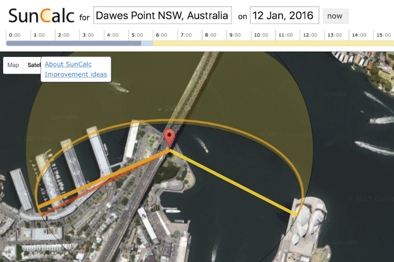
SunCalc is the main tool I use to plan long-term photo outings. After you pick the location you're interested in on the map, the yellow and red lines display which direction the sun will rise and set respectively.
As the sun's position varies throughout the year, SunCalc allows you to adjust the date to determine the best timing to align the shot you're after. In the above example, I wanted to know at which date was best to view the sun rising over the Sydney Opera House, from the vantage point of the Harbour Bridge's pylon lookout.
SkippySky

SkippySky is great at forecasting in advance those magnificent sunrises and sunsets we constantly chase. It's the site that determines whether it's worth sleeping in on the weekends.
Covering Australia, North America and Europe, the service (intended for astronomers) visualises the amount and type of cloud cover in your chosen area. The boxes above the map allow you to select your closest location, level of cloud cover (low, middle or high) and the time you want to forecast for. While the map may seem a little overwhelming at first, after some trial and error it'll train you into a meteorologist in no time!
As a rule of thumb, I find the more vivid colours to occur when there is high cloud overhead with little-to-no low cloud present. Also, look for low cloud cover to the east on sunrise (and to the west on sunset), which allows the sun rays to shine through and light up the overhead clouds.
WillyWeather

Another great tool that I use to check local conditions is WillyWeather. In addition to providing typical information such as temperature and forecasted conditions, it offers a wealth of knowledge to help ensure you are prepared for the right shot, at the right time. For instance, I use the site's data to help plan the following style shots:
Waterfall/River Long Exposure (local rainfall amount)
Coastal Scenes (tide levels and swell magnitude)
Astrophotography (moon brightness, in conjunction with SkippySky's cloud cover)
I'd love to hear if you know of any other useful sites that I should check out - please let me know in the comments below!